


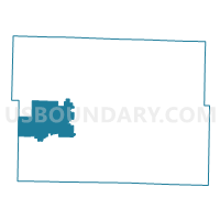
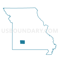
3rd Center Voting District, Greene County, Missouri
About
Outline

Summary
| Unique Area Identifier | 607877 |
| Name | 3rd Center Voting District |
| County | Greene County |
| State | Missouri |
| Area (square miles) | 40.49 |
| Land Area (square miles) | 40.47 |
| Water Area (square miles) | 0.02 |
| % of Land Area | 99.95 |
| % of Water Area | 0.05 |
| Latitude of the Internal Point | 37.23619100 |
| Longtitude of the Internal Point | -93.52208290 |
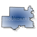
Maps

Graphs
Select a template below for downloading or customizing gragh for 3rd Center Voting District, Greene County, Missouri


Neighbors
Neighoring Voting District (by Name) Neighboring Voting District on the Map
- 1st Center Voting District, Greene County, MO
- 2nd Boone Voting District, Greene County, MO
- Brookline Voting District, Greene County, MO
- Murray Voting District, Greene County, MO
- Ozark Voting District, Lawrence County, MO
- Pond Creek Voting District, Greene County, MO
- Republic North Voting District, Greene County, MO
- West Republic Voting District, Greene County, MO
Top 10 Neighboring County Subdivision (by Population) Neighboring County Subdivision on the Map
- Murray township, Greene County, MO (6,647)
- Republic North township, Greene County, MO (6,468)
- West Republic township, Greene County, MO (3,949)
- Center No. 1 township, Greene County, MO (3,792)
- Brookline township, Greene County, MO (2,500)
- Center No. 3 township, Greene County, MO (1,811)
- Ozark township, Lawrence County, MO (1,658)
- Pond Creek township, Greene County, MO (1,583)
- Boone No. 2 township, Greene County, MO (863)
Top 10 Neighboring Unified School District (by Population) Neighboring Unified School District on the Map
- Willard School District, MO (23,600)
- Republic School District, MO (23,511)
- Ash Grove R-IV School District, MO (4,966)
- Miller R-II School District, MO (4,104)
Top 10 Neighboring State Legislative District Lower Chamber (by Population) Neighboring State Legislative District Lower Chamber on the Map
- State House District 134, MO (48,531)
- State House District 139, MO (39,224)
- State House District 132, MO (37,081)
Top 10 Neighboring State Legislative District Upper Chamber (by Population) Neighboring State Legislative District Upper Chamber on the Map
Top 10 Neighboring 111th Congressional District (by Population) Neighboring 111th Congressional District on the Map
Top 10 Neighboring Census Tract (by Population) Neighboring Census Tract on the Map
- Census Tract 50.02, Greene County, MO (6,737)
- Census Tract 49, Greene County, MO (5,973)
- Census Tract 4701, Lawrence County, MO (4,162)
- Census Tract 50.01, Greene County, MO (3,564)